Sub-5cm LiDAR Mapping For
National Projects

Latitude delivers terrain and elevation data that meets regulator standards, strengthens infrastructure safety, and accelerates donor approvals across the Caribbean and Latin America.

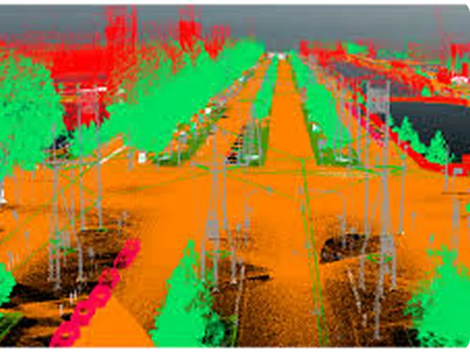
Sub-5cm LiDAR Precision for Compliance and Credibility

Infrastructure and environmental projects demand precise elevation data. Without defensible LiDAR outputs, agencies risk compliance failures, cost overruns, and safety gaps. Regulators and donors now require projects to prove accuracy, resilience, and transparent reporting before funding or approval. Enterprises that cannot show sub-5cm precision lose both time and credibility. 

LiDAR Mapping

Sub-5cm Accuracy for Safer
Infrastructure 

Latitude delivers geospatial big data processing and AI-powered analytics tailored for Caribbean and LATAM operations. 

Ensure compliance

Generate elevation models that meet international and donor accuracy standards.

Environment

Train staff in modeling and reporting for donor-funded projects.

Maritime

Enhance coastal monitoring capabilities for security and compliance. 

Our Strategic Partners

Our LiDAR Mapping Process

Latitude delivers geospatial big data processing and AI-powered analytics tailored for Caribbean and LATAM operations. 

Acquisition

Collect LiDAR data using UAVs and aerial systems tailored to project scale. 

Processing

Convert raw point clouds into digital terrain, surface, and elevation models.

Validation

Align outputs with regulator and donor accuracy thresholds before delivery. 

Applying LiDAR Across Sectors

Agriculture

Irrigation and drainage planning with accurate elevation models.

LiDAR Mapping

Energy

Corridor mapping for transmission lines and renewable sites.

LiDAR Mapping

Infrastructure

Road, bridge, and dam construction supported by sub-5cm terrain models. 

LiDAR Mapping

Environment

Floodplain and erosion risk assessments for compliance. 

LiDAR Mapping

Maritime

Coastal zone monitoring and shoreline protection planning. 

LiDAR Mapping

Government & Urban Planning

Master plans and zoning based on reliable elevation data. 

LiDAR Mapping

Applying LiDAR Across Sectors

Built for Governments. Trusted
by Donors. 

Latitude delivers platforms that withstand audits, meet regulator standards, and prove outcomes in the Guyana and Caribbean.