Latitude Sat2Farm combines satellite imagery, climatic data, and AI/ML algorithms to deliver real-time, field-level insights that help farmers plan smarter, irrigate efficiently, and protect crops against risks.
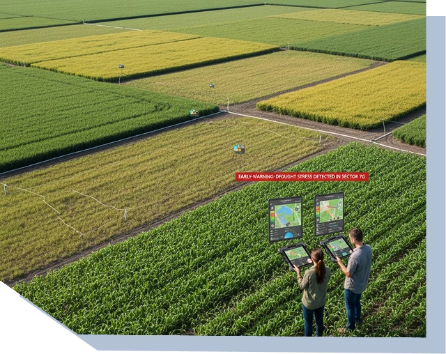
Uncertain weather, hidden soil issues, and undetected pests drive avoidable yield loss. Without timely forecasts, soil moisture visibility, and early-warning signals, inputs are wasted and interventions come too late.
Latitude Sat2Farm is a cloud and mobile platform that simplifies precision agriculture. It fuses satellite imagery, climatic data, and machine learning to transform complex agronomic data into actionable insights. Through one interface, users can:
From smallholder farms to regional agriculture programs, Sat2Farm delivers clarity, efficiency, and measurable resilience.

Latitude FieldForce digitizes field operations, giving agencies and enterprises a single platform to capture, validate, and report on-site activities.
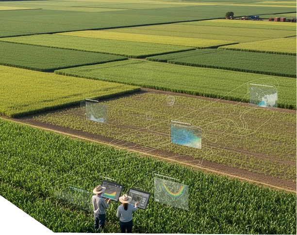
Detect stress early with NDVI/EVI/RVI trend analysis and plan harvests with 15-day forecasts.

Use nutrient mapping, irrigation advisories, and prescription maps to apply the right input, at the right time, in the right place.

Access soil moisture data, weather alerts, and pest/disease forewarning to reduce crop losses and stabilize productivity.

Latitude delivers platforms that withstand audits, meet regulator standards, and prove outcomes in the Guyana and Caribbean.
Monitor crop vigor, receive irrigation alerts, and apply inputs precisely to improve yield and reduce cost.
Track crop conditions and water stress across districts for regional planning and targeted advisories.
Measure program outcomes with yield trends, index-based resilience metrics, and alert-response data.
Integrate field insights into supply chain decisions, sustainability programs, and resource planning.
from the Guyana Manufacturing & Services Association for innovation supporting transport, mining, and infrastructure.
to improve yield forecasting, resource use, and climate resilience.
ensuring consistency with regional agricultural standards.
and data-science experts ensure model accuracy and data integrity.
Latitude supports national and enterprise programs with defined delivery standards, secure data systems, and technical services designed to meet audit, regulatory, and operational requirements across Guyana and the Caribbean.