Explore our cutting-edge solutions designed to elevate your business, from geospatial analytics and AI-driven insights to precision mapping and strategic planning. Unleash the power of technology for unparalleled success.
Geospatial Integration in Strategic Planning: A Roadmap for Success GIS evangelism is necessary to break down barriers and promote the incorporation of GIS into regular business processes and decision-making. Linking the geospatial strategic planning process with the organizational strategic planning process provides a shared plan to achieve goals. Integrating Geographic Information Systems (GIS) into strategic …
Accurate and secure GIS data is the foundation for informed decision-making. We provide comprehensive data creation, conversion, and collection services to ensure you have the right information for your needs. Benefits: Confident Decision-Making: Make informed choices based on reliable and secure data. Streamlined Operations: Efficiently manage your data with our seamless conversion services. Accurate & Up-to-Date Data: Get …
The Era of the drone is upon us For long, we have ignored the unparalleled advantages of using the medium of commodotized flight to propel human productivity. The technological challenge of extracting meaningful data from petabytes of aerial information, lack of standardized and secure flight workflows and a rapidly changing regulatory environment have restrained the …
Enterprise GIS Implementation GIS is a critical tool that can transform business operations and service delivery across an organization. Enterprise GIS unifies GIS technology and workflows across departments to create a standard, enterprise-wide system that can be efficiently managed and used by individuals throughout the organization. An enterprise GIS ensures a central, authoritative data source …
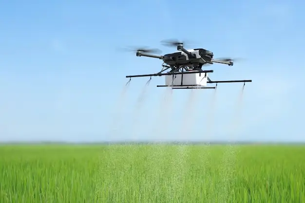
Simplify the complexity of precision farming GeoPard is an unbiased cloud-based Analytics Powerhouse for agricultural data. The platform core is capable of processing any set of geospatial data. We help our clients integrate into their business processes and their applications. GeoPard make the onboading process as fast as possible. Software integration is ready in a …
Get to Know About us We are a technology-driven GIS Services & Spatial Data provider that offers creative solutions in the areas of Location-Based Technologies and Location-Based Intelligence. Our principal focus is to provide cutting-edge technology services and a consistent forward-thinking approach to serving our customers. We take a collaborative approach, working hand-in-hand, listening to …
Industries Control the chaos of fleet management in any industry Amazon Delivery Reduce wasted time and costs by managing your Amazon delivery fleet with a centralized fleet management software. Aviation Fleet Take control of your maintenance workflow including expenses while reducing downtime for all of your aircraft fleet assets. Construction Automate construction fleet operations to …
We design custom GIS applications and IT solutions to fit your specific needs, no matter the size or complexity of your project. Our Services: High-Quality Development: We follow strict standards and use the latest technology to build reliable and powerful GIS applications. Scalable Solutions: We design applications for businesses of all sizes, from small startups to large …
90% of goods are transported by sea, new maritime routes are opening up and pirate ships and illegal vessels are ever- present…All a ship has to do is to cut its embedded active beacon (automatic identification system, for example) to vanish from the surveillance screens!Unseenlabs’ innovative electromagnetic technology enables it to track any vessel, anywhere …
We create detailed Digital Surface Models (DSMs) and Digital Terrain Models (DTMs) using advanced technology. These models reveal valuable insights for various industries, from urban planning to natural resource management. What We Offer: DSMs: Capture the Earth’s surface, including buildings, trees, and other features, for accurate 3D modeling and analysis. DTMs: Show the bare earth, excluding above-ground …
We know your success relies on your people. That’s why we offer consulting, advising, and training to empower individuals and teams in the geospatial industry. Our Services: Strategic Consulting: Get expert guidance to leverage geospatial technology effectively. We’ll help you find new opportunities, overcome challenges, and optimize workflows. Expert Advising: Our advisors have years of experience and …
Land & Hydrographic Surveys: Chartered Surveyors Latitude Geospatial is an established company of chartered surveyors, with over 20 years of experience utilising the latest innovations in survey equipment and technology, providing a full range of survey services throughout Guyana. Hydrographic: Latitude Geospatial are the Guyana’s leading independent coastal survey company, with extensive experience and a proven …
Our services enable organizations to develop a GIS-specific strategic plan that ensures that departmental and corporate leadership are on the same page
GIS Data Creation, Conversion, and Collection
Uncover the reason why accurate and secured digital data is a vital component of a genuine enterprise solution. Allow us to reveal to you how our team makes plans, design, and build reliable GIS
UAVs (Drone) Solutions
Our Aerial Imagery Services utilize UAS (Unmanned Aerial System), these are a faster, safer, and more cost-efficient way to survey utilizing specialized aerial photography UAV's. Our UAVs are equipped with high precision RTK GNSS processing,
Enterprise GIS Implementation
Enterprise GIS is the implementation of GIS infrastructure, processes, and tools at scale within the context of an organization, shaped by the prevailing information technology patterns of the day. It can be framed
GIS Data Analysis
There are many types of models, analyses, methods to address a question and extract information from spatial data. We provide different types of analysis services that give our clients insight into their data enabling them to better understand.
Geospatial Big Data Analytics, ML and AI
We provide big data analytics as SaaS to enable data-driven solutions based on scalable innovative algorithms that leverage advances in Satellite Remote
Artisanal and Semi Industrial Vessel Monitoring Systems
We provide big data analytics as SaaS to enable data-driven solutions based on scalable innovative algorithms that leverage advances in Satellite Remote
Application Development and Information Technology
We can help develop your GIS applications using quality assured application development methodologies, whether for large, medium,
Satellite Imagery and Remote Sensing Services
Satellite imagery provides a vast amount of information at competitive prices. This revolutionary technology offers enhanced
Digital Elevation Models (DEMs)
We create Digital Surface Models (DSM) and Digital Terrain Models (DTM) using satellite, LIDAR, and drone imagery
Consulting, Advising, and Training
It is the people in an organization who will determine its success or failure. Not technology. Not funding. The people. It goes
Land Surveying and Mapping
We provide a wide variety of land surveying services for public- and private-sector clients. From construction layout of high-rise steel structures to 3-D laser scanning, we perform comprehensive surveying